How Transit Displays GTFS Data
Transit has many different features that display GTFS data from transit agencies. Knowing how GTFS is displayed in the app can help producers understand where their data ends up, how it is used, and how it is interpreted by riders.
For information about producing clear GTFS static data, see our Data Guidelines page. For information on how to use Transit, see our User Support section.
In this article:
Nearby

The Nearby screen is the main screen of Transit. Here you can see information about all routes near your location that are scheduled to depart within the next 90 minutes.
- The transit map is the main map, and shows the larger network in your area, without a line needing to be selected. This map shows all the rail lines (route_type=0,1,2,5,6,12) and BRT systems (some routes with route_type=3,11) in the city.
- Transit generally displays the route_short_name as the main line indicator. In situations where the route_short_name does not exist or is not relevant for rider information, Transit displays the route_long_name. To match as much as possible what riders see while travelling, a mode image and/or a route image can partially or totally replace the route_short_name and/or route_long_name.
- The name of the direction comes from the stop_headsign if one is provided, or the trip_headsign if not. If both stop_headsign and trip_headsign are not provided, Transit displays the name of the trip’s last stop.
- The number on the right comes from the departure_time provided for the stop mentioned at the bottom left of the line’s cell in the “Nearby” screen.
- The departure time will be labelled LAST if it is the last departure of the day. If the last departure is after midnight, it will still be considered the last departure of the service day as long as there is a 3-hour gap until service restarts later that day.
- Routes that do not have trips within the next 90 minutes but do have scheduled trips within the next seven days will be listed in the "Inactive Lines" at the bottom of Nearby. These routes will become active when their next departure is within 90 minutes, and will remain visible for up to 15 minutes after the last active trip.

trip_short_names and branch codes are displayed next to the relevant trip_headsigns
- If the following three departures do not have the same headsign, Transit's “Nearby” screen splits these departures, arranging destinations underneath the direction. If trip_headsign is in the form "<cardinal direction> to <destination>", Transit will automatically format the headsigns by direction. Otherwise, the entire headsign is displayed
- trip_short_names should be populated only if they are used by riders and reflect a unique trip per route, per day, such as train numbers. Other information such as destinations or service types should not be added in this field.
- Branch codes are displayed in the same manner as trip_short_names. Transit will automatically recognize letter branch codes if the trip_headsign begins with a single letter character followed by a hyphen. Check the Transit data guidelines to ensure they are formatted correctly. For more custom branch code formatting and display, email us at data@transit.app.

The route cell can be swiped left or right to display the different direction_ids
Generally, a route has two directions, so the cell can be swiped once to reveal the other direction. The cell cannot be swiped in case of a unidirectional loop route, for example.

route_color & route_text_color will appear in the cell of a route
- Transit may change route_color and route_text_color values if they are not consistent with paper or online communication materials or if they do not meet sufficient contrast requirements.
- In metropolitan areas with many transit operators (e.g. Los Angeles), route_color can be used to distinguish agencies, and the color should be unique to the entire agency.
- The route_color will be displayed in Search Results, Route Details, and the background of the route's cell in the “Nearby” screen. route_text_color will be used for the text appearing in these three places.
Refer to Transit’s GTFS guidelines for more information on selecting good colors.
Route Details

Route details are accessed by tapping a route from nearby
- Agency logos can be displayed in the Route Details screen, but like all other images, these must be sent to Transit in SVG format.
- Accessibility information can be displayed, but users must turn accessibility preferences on in their Transit settings to see this information. Check the accessibility section for more information.
- When real-time data is available, a vehicle image is displayed on the map to represent the vehicle’s current location. This image is based on the route_type and may be easily changed to a different vehicle image to improve the user experience. However, this image must represent an actual vehicle and must not be a logo.
- If a route has multiple itineraries with active trips in the next 7 days, all shapes for those itineraries will be rendered on the route map, however they will have a higher transparency than the regular route shape.

If a route has more than one destination or branch, they will be displayed in their departure order
When viewing Route Details for an inbound direction from the end-of-line stop, the departure will be marked "DROPOFF ONLY." By default, riders do not see this direction unless they specifically swipe to reveal it. However, if a stop is explicitly designated as drop off only in the data, this information will be displayed beneath the ETA card.

On the stop list, you can see all the routes that connect at each stop
- The stop list displays all the next stops of the trip, starting from the stop selected
- The row below each stop name shows the routes the riders can transfer to at that stop. Transit shows all connections across all transit systems offering service within 100 meters of the stop listed. All routes in the GTFS are displayed, even if they do not have departures within the next 90 minutes.
-
The routes displayed under the stop name will be grouped by mode and represented either by a route image or their route_short_name
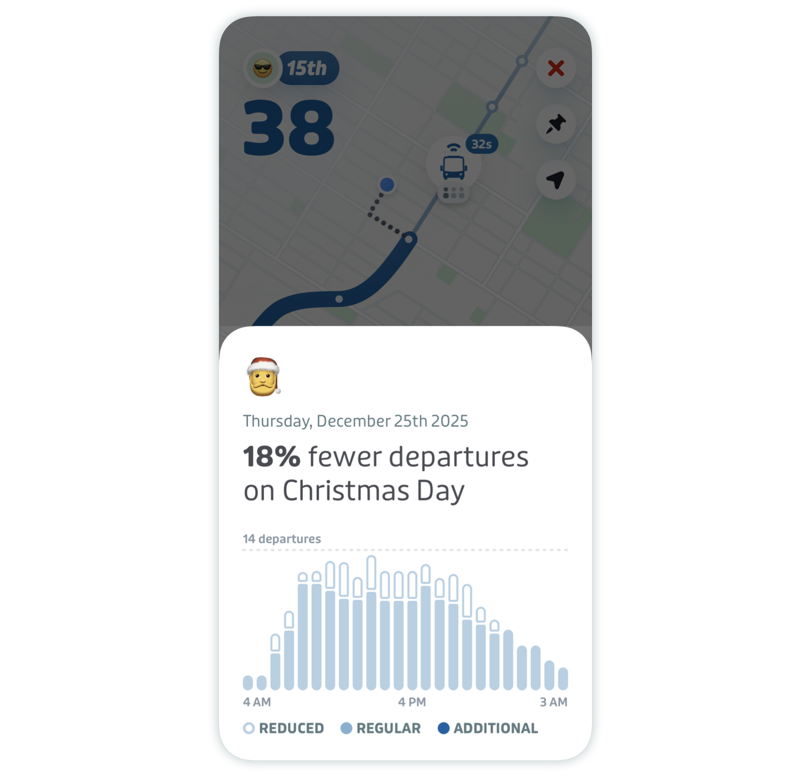
Holiday Card
- Within 5 days of an upcoming holiday, Transit generates a holiday service change card that appears on the Route Details screen. Tapping this card opens a sheet with additional information, including the name and date of the holiday, along with a chart showing the change in the daily number of departures for that route as compared to a week before. Holidays for each region are obtained from the date-holidays library. Holidays with a type of observance are ignored.

Schedule

The schedule view lists all the upcoming departures for a route at the current stop
- By selecting "More departures" in Route Details, you can access all destinations and their departure times from your stop.
- By Default, Transit downloads up to 4 weeks' worth of schedules. If schedules for the next 4 weeks are not available to users in the app, it may mean the most recent GTFS dataset Transit downloaded was valid for less than 4 weeks.
Search Results

Search results contain information about routes and stops that users may be looking for.
- By tapping on the search bar in Nearby, a user may search for routes, stops, or locations
- Searching for a route allows users to see both the route_short_name and route_long_name when both are provided
- Searching for a stop allows users to see the stop image, which contains any logos displayed at the top of stop poles or on station entrances. When no stop images are defined by the agency, the app will display a default vehicle image based on the route_type.
Trip Planner

In the trip planner, you can see all information relevant to the available trips for your destination
- When a user taps on a stop or a location provided in the search results, Transit will suggest several trip plan options to the chosen destination
- Fares will appear next to each trip option when available and provided. Find more information about Fares V2 in Transit’s data guidelines and the GTFS specification.
Trip Details

Once a trip is selected, details about your route are provided.
- When a user taps on a suggested trip plan, Transit will show the trip plan's details.
- As in Route Details, the route shape is taken from the shapes.txt file.
- Pathways information, if provided, will display as part of step-by-step navigation information provided on this screen.

Settings

Access your settings by tapping on the gear icon in the top left corner of the main screen (Nearby). Then, tap "Public transit" to toggle nearby systems on and off.
- The "Public transit" section lists all the available nearby transit systems along with their associated agency
- This information is organized by route_type and the agency name. However, mode names may be localized for accuracy.